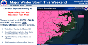
- NWS There will be one area in this storm across SE NC that will see the fire hose effect of snow with 12”-15”+ inches.
- Winter Storm Watch has been upgraded to a Winter Storm Warning.
- A Cold Weather Advisory has been issued for parts of the area tonight through early Saturday evening. An Extreme Cold Watch remains in effect for early Saturday evening through Monday morning.
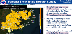
- Snow onset is trending earlier (Saturday morning)
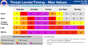
- High confidence in extremely cold air for the area this weekend, creating significant, rare wind chills.
- Increasing confidence for significant snow and associated impacts.
- High confidence in hazardous winds and seas for the coastal waters over the weekend, creating dangerous conditions for mariners.
- Dangerous cold seeps in tonight, with single digit wind chills Saturday night and Sunday night.
- Confidence continues to increase of significant snowfall across much of the forecast area.
- The potential for heavy snow banding may produce localized swaths of heavier snowfall, especially north of the Cape Fear region.
- Dry and powdery snow combined with strong and frequent wind gusts of 25 to 35 mph will result in particularly dangerous driving conditions, causing poor visibility and reduced traction. Scattered power outages expected.
- Gale force winds likely over the coastal waters late Saturday into Sunday, with a few gusts up to storm force possible, particularly from Surf City, NC to Little River Inlet, SC.
- Extremely cold temperatures bring wind chills well into the single digits, potentially into the negatives Saturday night and Sunday night.
- Due to expected prolonged cold, hazardous travel conditions could extend through the early to middle part of next week.